
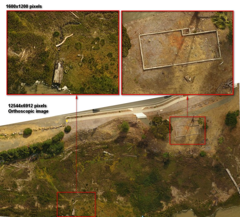
With a very high-resolution custom map, your team can zoom in on your areas of interest in fine detail. In the photo above, this portion of marsh land is about half a mile across, and the resolution is shown on this page at 12544 x 6912 pixels. The actual custom map is about three times this resolution – you can expect much more detail than is possible on this website. The image shown above is just a small portion of the 2 mile area that was photographed and mapped. The landscape in this photo is inaccessible by hikers or walkers because it is a marsh land.
Once you zoom in, small items or even a pack of cigarettes is visible on the ground. You will be able to see clearly a pile of lumber or driftwood on the beach, and the light footpaths worn through vegetation created by animals. In this example you can see the water drainage path, individual wood planks, old vehicle tires, and different types of debris visible around the shoreline. The second cut-out photo shows an old building foundation about the length of two cars. In it, you can clearly see the 4 x 4 wood foundation piers and even small rocks on the ground.
If you choose a photo series, a longitudinal photo study, the movement of debris, plant growth, and changes to larger items will all be clearly visible. There are many practical applications for large area custom 2D & 3D mapping – agriculture, civil engineering and city planning, construction, law enforcement and emergency services.
Emergency services are available in time-sensitive situations when time is critical. We can fly along a general path with control points, or work with you side by side while viewing the live video.
Please feel free to look through my portfolio and contact me here.


© Aerial Perfectionist. Greater Bay Area Aerial Photography & Videography.
